Multi-Node Lightning Localization & Wildfire Ignition Watch
Authors: Samuel Watson (University of Hawaiʻi at Mānoa / HCDP)
Sage Summer Camp 2026 · Sage user scwatson · camp blade H03E
Sage FlashPoint turns the Sage fleet's existing cameras, microphones, and weather stations into a lightning-detection and wildfire ignition-watch system. Weather feeds arm the nodes ahead of a storm, the sky camera gives each node a free absolute time-zero (the flash), the microphone gives range (flash-to-bang), multi-node geometry gives location, and every strike becomes a multi-day holdover-fire watchpoint with camera smoke monitoring and human-reviewed risk notifications.
What the system can do
- Detect lightning on node sensors. A noise-adaptive, spectrally-whitened thunder detector finds thunder onsets even in rain noise; a scene-luminance flash detector uses the sky camera as a photometer (no aiming needed) and assigns fisheye azimuth sectors.
- Localize strikes without clock synchronization. Light arrives
effectively instantly, so each node's flash→bang delay is a self-clocked
range (
r = Δt × c_sound). Ranges from several nodes trilaterate the strike with an honest uncertainty ellipse; GDOP/degeneracy gating reportsfix | ambiguous | range-onlyand never over-claims. - Arm itself before the storm. A tiered controller (IDLE→OUTLOOK→APPROACH→STORM→AFTERMATH) escalates capture from NWS outlooks through radar cell tracks to continuous storm capture, with guardrails (daily budget, storm-hour cap, timeouts, hysteresis) and a full audit trail. On a replay of the real ignition storm it armed 145 minutes before the first local flash.
- Watch every strike for holdover fire. A risk-ranked patrol skill re-aims a PTZ camera through recent strike sectors on a revisit schedule, ships before/after evidence pairs (raw frames never modified; overlays only on derived copies), and scores each strike for ignition risk (rain at the node, soil/fuel dryness from NASA POWER, fuel type, detection confidence).
- Keep a human in the loop. Alerts land in Slack as a glanceable card — headline score, one summary line, inline evidence strip — with the full forensic breakdown in-thread. Reviewers click Confirm / False positive / Keep watching / Comment; decisions flow back over Socket Mode, are logged as an audit trail, and double as labeled training examples. Nothing is ever auto-dispatched.
- Show its work. A Streamlit dashboard (node map + fire records, multi-node image comparison, synchronized image–audio–met timelines, range rings and strike solutions) and standalone Leaflet strike maps make every step of the chain inspectable.
The problem it solves
Lightning-started wildfires are frequently holdover fires: the strike is brief, ignition smolders unseen for hours to days, and discovery comes only after the fire is established. The Kitten Fire (Grand Teton, July 2025) started 6 km from Sage node W06C — a node with a microphone, cameras, and a weather station that recorded through the entire ignition storm. The node heard the storm, but nothing was listening for it; its PTZ camera pointed at a cabin wall the whole time. Commercial lightning networks locate strikes but don't watch them afterward; satellite fire detection sees the fire only once it's big enough. FlashPoint closes that gap on infrastructure that already exists: detect the strike, localize it, judge whether conditions favor ignition, and keep a camera on the spot through the holdover window.
What it contributes
A validated design thesis: single-modality detection false-alarms confidently; fusion plus external anchoring is mandatory. The first-pass audio-only detector produced 17 confident thunder candidates — and dual-satellite GLM cross-validation (GOES-18 and GOES-19) falsified all 17. Satellite-anchored re-listening then recovered 22 real flash→bang arrivals that rain noise had hidden. That falsification→recovery arc is now the architecture: standalone detections are nominations only; range claims require an anchor (camera flash, satellite, or RF).
Working, tested software, end to end (all in the project repository, all with test suites):
detectors/— noise-adaptive thunder + flash detectors with anchored listening windows and range-consistency gatingplugin-thunder/— the thunder detector packaged as a Sage/Waggle ECR plugin (pywaggle); built and run on a Sage node, with detected candidates published to and verified in the public cloud query APIcontroller/— the storm-mode state machine with budget guardrails, live feeds (NWS free-tier; Xweather polled only when elevated), and a replay harnessfusion/— flash-coincidence incident grouping, cross-node candidate RANSAC, GDOP-gated solver, strike-map generationrisk/— transparent ignition-risk score with per-factor provenance, Slack delivery with the raw+annotated evidence rule, Socket Mode review loopagent/— smoke-watch skills forwaggle-sensor/sage-agent(risk-first sector patrol, evidence renderer, test panoramas), validated end-to-end through the real sage-agent gateway on the camp node: the true plume flagged, the confuser reel clean (test-mode PTZ, live vision captions)dashboard/— the forensic workbench used to build and audit all of the above
Findings returned to the Sage program: no soil/fuel-moisture sensor publishes anywhere on the fleet (a LoRaWAN soil probe would be the first); the manifest is not the archive (97 nodes advertise microphones but only 64 ever published audio; four record audio with none listed — including W021 in Colorado, which overturns the earlier manifest-based finding that Colorado has zero microphones); the fleet's two most fire-exposed recording nodes (V040 and V041, Oregon — 55 and 53 natural-cause fires within 35 km) ran their microphones only in autumn and winter, capturing zero of their 35 storm days; node liveness is task-level — W096's imagesampler sat silent for 24+ hours while its met and audio tasks kept flowing, so "node up" is not "camera up"; two documented cases of PTZ cameras idle or mis-aimed during ignition-relevant windows; per-node file-ACL map for the fire-country case-study nodes.
Data collected and validated
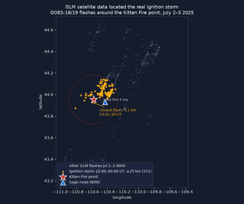
- Kitten Fire retrospective (flagship case): 518 archived W06C audio clips (Jul 2–3 2025) classified; 17 audio-only candidates falsified 0/17 by dual-GLM; the real ignition storm located by GLM fire-point scan (219 flashes ≤ 25 km in 2 h, closest 3.1 km from the fire point, ~3 h before discovery); 22 flash→bang arrivals recovered from the archive and kept as ground truth. Independent news corroboration: 4,000+ strikes and 8 fire starts reported in the region that week.
- Detector validation on the real storm: 20/22 anchored arrivals recovered, median range error 0.6–0.8 km (inside GLM's own 8–14 km pixel scale); rain-control false-alarm rate ~36/h standalone — the measured justification for the nominate-only contract.
- Satellite-free localization: integration test fuses camera-flash anchors
- thunder across nodes to a 96 m fix with no satellite and no clock sync; the fusion replay places 5/5 strikes as clean fixes at 70–273 m error.
- Controller validation: replayed against the real Kitten storm feed — armed 145 min ahead of the first local flash, scheduled the holdover watch, expired cleanly; 19/19 tests.
- Risk score back-test: both real ignition storms score 87 and 84 of 100; a wet-storm control scores 41; a no-strike day scores 0. Dryness input verified live against NASA POWER (GWETTOP 0.460 at the Kitten point, 2025-07-01).
- Selma bust (second case): 14 natural-cause fires discovered in one day near W067; node gauge 0.05 mm all week; SMAP PM soil moisture 0.084 — a textbook dry-lightning bust captured in fleet met data.
- Supporting datasets: W06C event-window archive (779 audio clips, 2,739 PTZ frames, 51k+ met records), W097 forensic imagery set, WFIGS wildfire records cross-referenced to node positions, fleet census (103 Chicagoland nodes; 51 mics, 51 cameras), TDOA feasibility Monte Carlo on real geometry (median 135–331 m depending on onset timing noise).
- On-node validation (H03E, ARM64): all seven test suites green on the camp Thor blade; the archive eval reproduced on-node (20/22 recall, 0.8 km median range error); the edge plugin ran on the node with candidates published to the cloud API (task=thunder, vsn=H03E); the smoke-watch skill ran through the real sage-agent gateway — flagging exactly the true Halemaʻumaʻu plume and nothing on the confuser reel — surfacing three integration findings the standalone tests could not catch. A follow-up agent-ladder run then verified the cloud escalation rung live (glm-4.x-class via NVIDIA NIM: correct ESCALATE/QUIET text triage in 2–17 s) and moved the perception leg onto live data — real fleet frames from W09E/W08B through the local vision model, zero plume false positives. Hard finding from that run: the NIM endpoint silently drops image parts, and the model hallucinates a scene if pixels are attached — the cloud rung is therefore text-triage only, enforced in config.
- First neural result — audio classifier probe v0: frozen YAMNet embeddings + logistic regression, 5-fold CV: AUC 0.952 vs 0.699 for the DSP score on the same labels; at a 1-false-alarm/hour operating point it recovers 15/22 arrivals where the DSP recovers 1. The rain-masked thunder the DSP cannot separate is separable in the embedding.
- Fleet-history storm catalog (Jetstream2, complete): 7.05 million GOES GLM granules read across 1,140 satellite-days (2021–2026, all four GOES satellites, boundaries verified against the archives); 353 natural-cause fires within 35 km of a sensing node; 2,263 storm days scored for archive coverage; 448 (fire, node) pairs ranked as retrospective candidates, with the Kitten Fire landing at #4 — and the scanner independently reproducing M1's nearest-flash distance (3.13 vs 3.1 km) and dry/wet rain split before any bulk run. Snapshot audio captures only 0.6–2.3% of storm wall-clock — the quantified case for storm mode. 54 dry-lightning candidates identified across 11 nodes.
- Live delivery validated: risk cards posted to Slack with inline evidence strips and working review buttons; reviewer decisions logged end-to-end.
Case files
Two of the wildfire cases uncovered by this project, told through the node's own data.
Audio ships in pairs, per the project's evidence rule: the -raw.flac clip is the
untouched sensor recording; the -listen.flac clip is a labeled derived copy,
gain-normalized so a human can hear it (thunder 10–20 km out arrives at
~0.4 % of full scale — real but nearly silent).
Case 1 — Kitten Fire (Grand Teton WY): the node heard the ignition storm
Fire discovered midday 2025-07-03, six kilometers from Sage node W06C. The node's microphone recorded straight through both suspect storms:
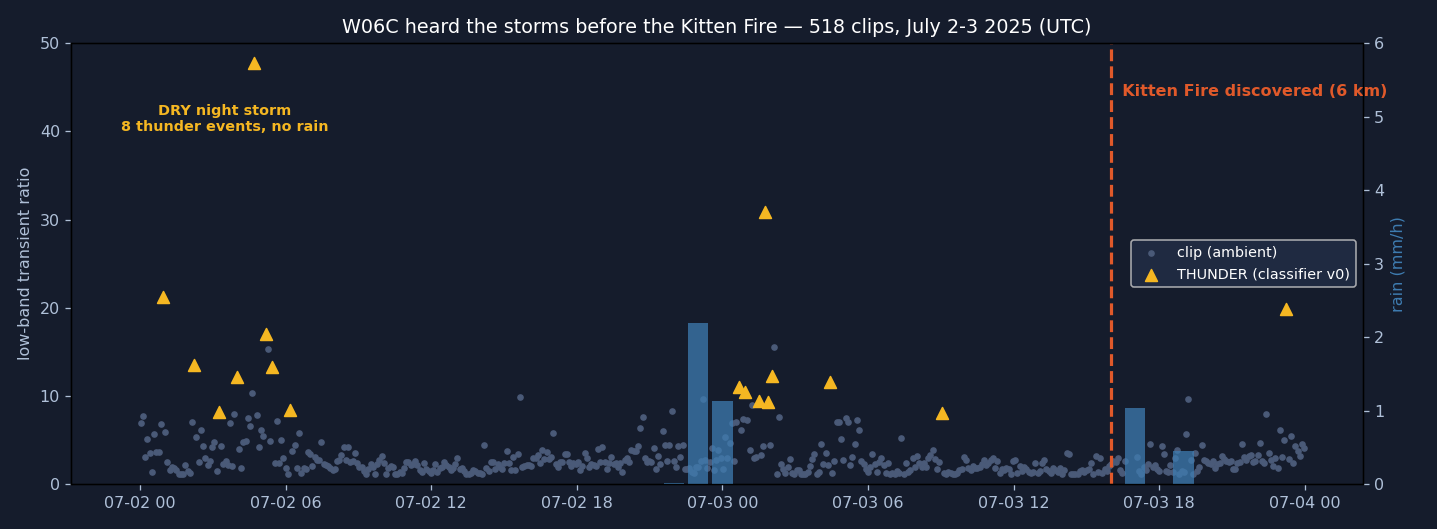
The audio-only classifier flagged 17 thunder events — and dual-satellite cross-validation falsified all 17. This was the strongest of them (low-band transient ratio 31, the burst at ~23 s), yet neither GOES-18 nor GOES-19 saw a single flash within 50 km:
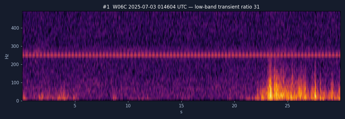
🔊 Hear the false positive:
raw · normalized +38 dB
— convincing to the ear and to the v0 detector; of undetermined origin per two independent satellites. This one clip is why FlashPoint's standalone detections are nominations, never confirmations.
Satellite data then found the real ignition storm — and anchored re-listening recovered the thunder that rain noise had buried:
With each GLM flash as a time anchor, the detector re-listened in the predicted arrival windows and recovered 22 flash→bang arrivals. Two of the strongest, with their spectrograms and the actual recordings:
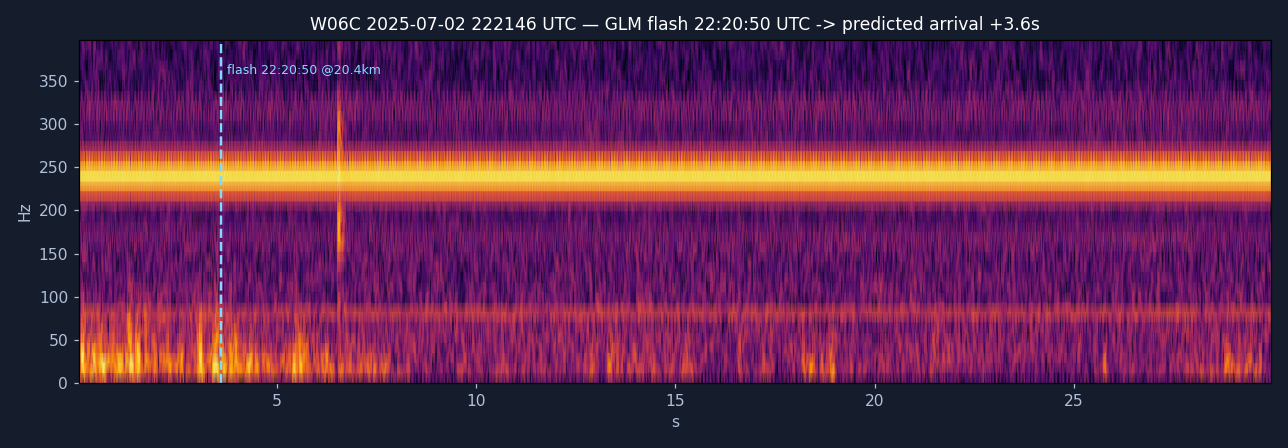
🔊 raw · normalized +47 dB
— the GLM flash fired 20.4 km away at 22:20:50; sound needed 59.6 s to reach the node, landing +3.6 s into this clip, exactly where the detector found the onset.
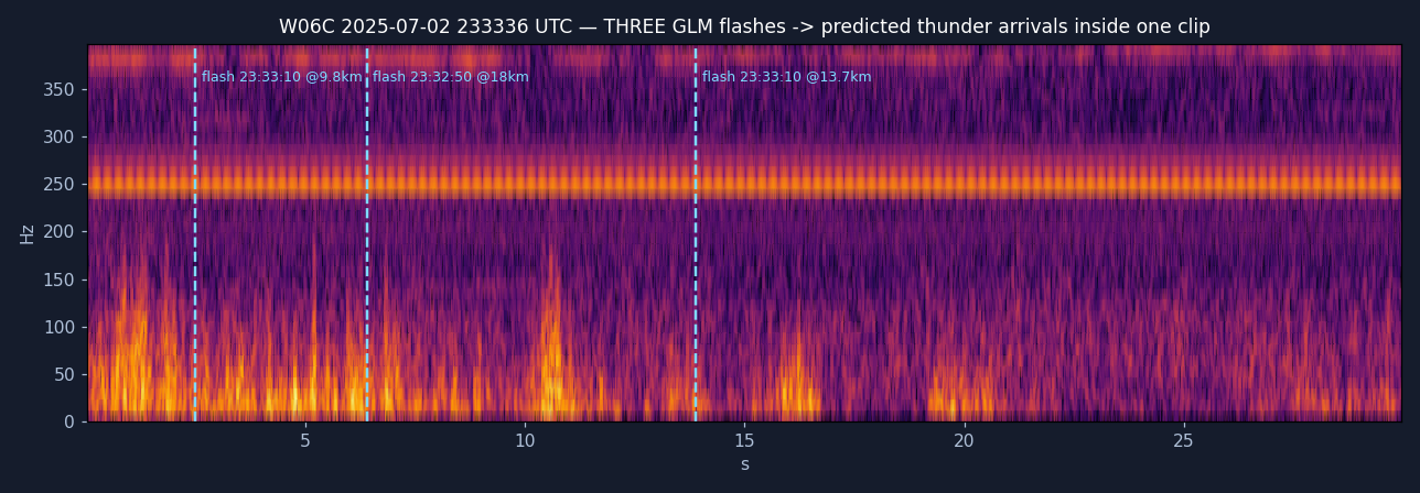
🔊 raw · normalized +45 dB
— a volley: three separate flashes at 9.8, 18.0 and 13.7 km, three arrivals inside 11 s, each at its own predicted delay.
And the frame that motivates the whole storm-mode controller — what the node's steerable camera was doing during the ignition storm (top two rows) and during the falsified events (bottom row): pointed at a cabin wall.
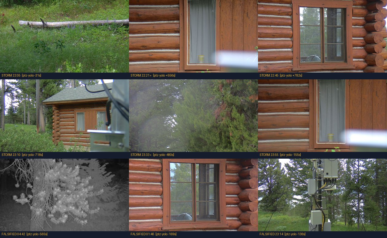
Two distinct failures hide in this image, and honesty requires separating them. The first is tasking: nothing told the camera a storm was happening — that's the problem the storm-mode controller solves. The second is siting, and no software fixes it: W06C sits low among trees and cabins, so even a perfectly aimed PTZ almost certainly had no sightline to a smolder 6 km away through lodgepole forest. Concretely, SmokeyNet scores a horizon band of the frame — and W06C's "horizon" is a treeline meters away. The legs of FlashPoint that don't need a view (thunder ranging, the met station, and in principle even flash time-zero — lightning lights the whole scene, cabin wall included) survive bad siting; visual smoke confirmation does not. See the camera-siting recommendation under Future directions.
(The same node's second chance came three weeks later: the Signal Flat fire, 2025-07-26, 12 km out — same pattern, nobody listening.)
Case 2 — Selma bust (Siskiyou OR): fourteen fires, five bone-dry days
No lightning detector needed to see this one coming. Node W067's own weather station recorded a 37 °C heat spike and 0.06 mm of rain across five days; then WFIGS logged 14 natural-cause fire discoveries in a single day, 14–34 km from the node. The gauge's only movement of the whole window — a 0.05 mm trace — arrives exactly at the fire line: the passing storm itself. Textbook dry lightning:
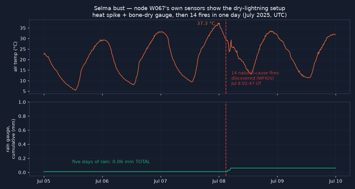
The node also captured hourly imagery through the bust, but its files sit behind a per-node ACL not granted to this project (403) — which is why W067 file access leads the camp access requests. Media provenance for everything above is documented in the project repository.
Future directions
- NLDN arbitration. A Vaisala research-data application (three case windows, ~65k km²) was submitted 2026-07-24. NLDN's ~100–150 m accuracy is the only reference that can grade the project's ~100 m claims and arbitrate the 22 recovered arrivals plus 72 newer candidates.
- Neural thunder classifier. Probe v0 (YAMNet embeddings + logistic regression, AUC 0.952 vs 0.699 DSP) validates the direction; next steps are more storms, the reviewer-click labels accumulating in Slack, and distilling the probe into the edge plugin.
- Smoke leg. Adopt the official
sage-smoke-detectionSmokeyNet plugin for the holdover watch (the patrol skill already enforces its dwell and horizon-band requirements), few-shot-tuned for non-California horizons. - RF time-zero (SDR). A sferic receiver replaces the camera flash as the per-node anchor — making zero-sync ranging work in daytime and through cloud, and enabling positive-polarity flagging (the disproportionately fire-starting strikes).
- Live PTZ actuation. Camera-control credentials on the sanctioned sandbox node (W0A4) are the unblock for exercising the patrol skill's re-aim commands against real hardware — the camera's live web UI and stream have already been reached through an SSH tunnel, so control permissions are the only missing piece.
- Work the retrospective queue. The fleet-history catalog ranks 448 (fire, node) pairs; Christ Mountain/W021 tops the list with a 0.14 km flash-to-fire match and 2,017 archived audio clips, and four W06C coincidences from July 2026 sit in the top 20. Each is an M1-style anchored re-listening waiting to run; every storm over a recording node is classifier training data; the per-node storm climatology calibrates controller budgets; and the ranking prioritizes node-access and NLDN window requests.
- First fleet soil-moisture stream via the camp LoRaWAN probe path, to replace the POWER/SMAP dryness proxy with in-situ readings.
- Camera siting for the smoke leg. The Kitten forensics show that low-sited cameras can't confirm smoke no matter how well they're tasked. Two paths, cheapest first: (1) use FlashPoint's strike fix + uncertainty ellipse to cue existing elevated camera networks (ALERTWildfire / ALERTCalifornia, HPWREN) — Sage's ears pointing someone else's high eyes; (2) a "wildfire sentinel" siting profile for future fire-country nodes: the camera goes on a ridgeline, tower, or decommissioned fire lookout with real horizon visibility, while the mic + met + compute can stay low where power and comms are easy. Sage already proves the pattern works where geography allows it — W097 overlooks the Kīlauea caldera, which is exactly why the holdover-watch test panoramas are built from its imagery.
Lessons learned
- Trust nothing single-source. The week's defining result was two satellites falsifying all 17 confident audio detections. Building the falsification into the pipeline (instead of quietly dropping the result) turned an embarrassing negative into the project's strongest evidence.
- Handle evidence like it will be audited — because it was. The archive's fire-detection job had burned detection boxes into the only stored copies of frames later needed clean; the boxes had to be inpainted back out, and the rule was adopted everywhere: raw files are never modified, overlays go on labeled derived copies.
- The constraint that matters may not be software. The initial assumption was that camera tasking was the gap; the Kitten forensics showed camera siting (viewshed) is the harder half, and no controller fixes it.
- Archive data has sharp edges. Per-node file ACLs, storage auth quirks behind sandboxes (worked around via the Sage MCP server's authenticated proxy), regex-typed query filters, in-enclosure temperature sensors masquerading as ambient — half of data science on a real fleet is learning which streams mean what they say.
- Cloud LLM rungs get text, never pixels. The escalation endpoint silently dropped image attachments — no error — and, prompted as if it could see, confidently hallucinated a building fire in a forest frame. A confident wrong answer with no error signal is the M1 failure mode at a different layer; the config now forbids images on the cloud rung and pins frame reads to the local vision model.
- Edge-first framing changes designs. Keeping raw audio/video on the node and shipping only tiny event records isn't just privacy hygiene — it's what makes storm-mode capture affordable within node budgets.
Limitations
- Hackathon time constraint. This system was designed and built in roughly one camp week. That budget forced choices that a longer project would revisit: the risk-score weights are hand-set (v0.1) and back-tested on only four scenarios; the detectors received fewer adversarial review passes than the dashboard; several integrations stop at validated dry-run sinks rather than live actuation; and evaluation depth everywhere traded against breadth of the end-to-end chain.
- One real storm validates the audio chain. Thunder-detector recall, range error, and the probe-v0 AUC all come from a single event (Kitten; 13 positive clips) — promising, not proven. The catalog's ranked queue of 448 candidate retrospectives is the path to widening this. Flash detection and fusion are validated on a replayed test storm over real node geometry — real multi-node flash+thunder captures don't exist yet because storm mode wasn't running when the archives were recorded (that's the point of the project, but it's still a gap until the next storm).
- Night-strong asymmetry. The camera-flash anchor is much weaker in daylight; daytime performance leans on satellite/RF anchors that aren't on the nodes yet.
- Low-sited cameras cap the smoke leg. Several fire-country nodes (W06C included) have no meaningful horizon view, so on those nodes the 72-hour watch can detect and localize the strike but cannot visually confirm ignition — that requires elevated partner cameras or better-sited future nodes (see Future directions).
- Ground truth is coarse, and the fine reference is not yet approved. GLM pixels are 8–14 km, so the sub-km range errors are measured against a reference fuzzier than the claim. A Vaisala research-use data request (NLDN-grade strike data for the three case windows) was submitted 2026-07-24 and had not been approved as of this writing; the Xweather API key's real-time endpoints work, but its historical archive is entitlement-walled on the pay-as-you-go tier.
- Node archive access was incomplete. File-level read access (imagery/audio) to several fire-country nodes was requested but not granted during camp week: W067 — which blocked the Selma imagery review — plus the Lakeview MT twins W084/W06F and W019 (Eugene). Additional applicable storm and wildfire case data likely exists in those archives and could not be examined; public numeric telemetry was unaffected.
- No live fleet control yet. Camp scheduling permissions on W-nodes are unresolved, so the controller drives dry-run/agent-scheduler sinks; the 22+72 recovered arrivals also remain unarbitrated by an independent ground-truth network until the NLDN request is decided.
- Live PTZ control remains unexercised. A hands-on session on the sanctioned camera-sandbox node (W0A4) reached the camera's web UI and RTSP stream through an SSH tunnel via the node — enough to observe how the camera behaves in a live setting — but PTZ control permissions were not granted during camp week. The patrol skill's re-aim commands are therefore validated in the framework's test mode only; live actuation awaits camera-control credentials from the node administrators.
References & data sources
Prior work this project builds on
- Sage / Waggle — the testbed, node hardware, data APIs, and the
audio-sampler,ptz-yolo, andsmoke-detectorplugins whose archives made the retrospectives possible. - sage-smoke-detection — official Sage SmokeyNet plugin (HPWREN/FIgLib-trained); the planned smoke leg. Its horizon-band + dwell requirements shaped the PTZ patrol design.
- sage-agent — the agentic PTZ framework the smoke-watch skills are shaped for.
- Sage Autonomous Camera Control (Dematties et al.) and the Sage SDR lightning project — the PTZ plumbing and RF third modality the future directions target.
- NDP "Sage Smoke Detection Workflow" (Ismael Perez, SDSC) — SmokeyNet preprocessing recipe adopted here.
Data
- NIFC WFIGS Incident Locations — the interagency wildfire incident ledger (IRWIN-fed): discovery records for Kitten, Signal Flat, and the 14-fire Selma bust. Fire cause is the responding agency's official determination — every "natural-cause" label in this work is a WFIGS attribution, not an inference. News is used only as corroboration, never as a case source.
- NOAA GOES-18/19 GLM on AWS Open Data — the dual-satellite lightning cross-validation and anchor flashes.
- NASA POWER (GWETTOP dryness) and NASA SMAP L3 (soil moisture at both fire sites).
- NWS API and Vaisala Xweather — storm-mode controller feeds.
- Sage data & storage APIs — W06C audio/imagery/met archives, W067 met streams, fleet manifests.
- Sage Grande MCP server — used two ways: its authenticated proxy endpoint carried every archive file download performed from cloud sandboxes (518+ audio clips and the case imagery; sandboxes strip Authorization headers, so direct Basic-auth downloads fail there), and its query/job tool suite was evaluated as the intended path for live storm-mode job control once scheduling permissions are granted.
- NASA Earthdata Login — account registered for SMAP L3 access; real soil-moisture retrievals obtained for both fire sites via CMR granule search + EDL token download.
- News corroboration: Buckrail, July 3 2025 — 4,000+ strikes and 8 fire starts on the Bridger-Teton NF the week of the Kitten Fire.
- Vaisala NLDN — research-data request submitted 2026-07-24 (evaluation-grade ground truth, pending).
Models & software
- YAMNet (Google Research, TF-Hub) — frozen audio embeddings for classifier probe v0.
- Ultralytics YOLO11 (yolo11n) — detection head in the sage-agent gateway runs.
- Gemma (gemma4:31b via Ollama) — vision captioning in the real-gateway smoke-watch validation; GLM-4.x-class escalation via NVIDIA NIM is the configured cloud rung.
- Leaflet 1.9.4 (vendored) — interactive strike maps; basemap tiles © OpenStreetMap contributors, © CARTO, and Esri.
sage_data_client, Streamlit + Altair (dashboard), NumPy/SciPy/soundfile (DSP), pywaggle (edge plugin).
Team & acknowledgments — Samuel Watson (UH Mānoa / Hawaiʻi Climate Data Portal); thanks to the Sage Summer Camp 2026 organizers for node access grants and to the Sage team for keeping five years of fleet archives queryable enough that a week-long hackathon could mine them. This work was supported in part by the National Science Foundation under Awards No. 2331263 and 2436842.